I just published a short story on my blog:
Beginnings - Michelle M Monagin
Check it out!
Wednesday, September 6, 2017
Thursday, September 30, 2010
Night on the Columbia River
The sun has gone down and it is dark in my camp, but the river seems to retain some of the light from the day. I can only see shadows of the mountains against the clear medium-blue sky; they might be the mountains, or they might be clouds. But, no, they must be mountains, because there are clouds above them.
Nearby I see the outlines of stumps and the line of the remnant of a pier against the silver water . On the farther shore, which is visible only as a darker outline, I see colored lights flashing on and off--green lights and red lights--I don’t know what they are or what they are for. The stars begin coming out one at a time as the river looses the sun’s light.
Off to the south-east, greater light betrays the existence of a city behind the hills. All else is in darkness. The land is black, the water grey, the sky a lighter grey with the light of stars peeking through.
There is the sound of traffic occasionally going by on the road nearby. Otherwise, there is no sound of mankind. Only the lapping of the river against the bank, the wind through the leaves of the trees, and, just once, the indignant quacking of a duck whose rest was disturbed.
All else is peace.
Saturday, September 18, 2010
North Bend, OR
I don’t like North Bend. Maybe I am wronging the city: it might be a perfectly nice city, brimming over with sense and hospitality. But that is not the face it showed me.
First of all, it was all hills along Newark, which is the road I needed to take. I went up one hill and down another just to go up the next. And these weren’t little hills, either. They were great big hills, and reaching the top took a real effort. And no sooner would I reach the top, then there was a precipitous drop and another hill. Maybe 30% grade.
Going over these hills, I was supposed to find a street called Broadway. I was looking for a bike shop that was supposed to be on Newark at the same time I was looking for Broadway, so naturally I missed Broadway (and I never did find the bike shop). So, having missed Broadway, I ended up at the end of Newark, and I didn’t know where I was or how to find my way--and, of course, there was no one to ask. Pulling out my map of Oregon, I found the street, ant found that I could get back to Virginia, Monroe, and Florida streets (which were marked on my bicycling map) by following it along. That particular street was not bicycle-friendly, but I did get to Virginia, and find Monroe.
However, I was unsure of where I was going, so I asked at a service station at Virginia and Monroe where Florida would be. The first response I received was “I don‘t know, I‘ve never heard of Florida street.” This from a local! And it was obvious that there would be a Florida, since they had every other street. But then, the woman who was working at the shop went and looked at her map, and found Florida for me: it was about 4 city blocks away.
So I was on my way--for a short while. There was a hill on Florida--not a high hill, probably only 15 feet--but it rose at least at 45 degrees! So, I walked my bike up the hill, and I did finally get to the top, only to find Sherman Street. Now, it wasn‘t clear that Sherman Street was what I was looking for. According to my map, I was looking for the 101 out of the north side of town, and there was no indication that Sherman street was the 101. So I went into a store to ask. The young man behind the counter looked at me blankly for a few moments, and I thought he didn‘t understand my question. I was pretty sure it wasn’t a linguistic difficulty, as he did not respond at all. It was more like someone having difficulty processing information. When he finally spoke, he slowly told me that Sherman Street was the 101, and would take me out of town. So, I was definitely on my way, now.
Unfortunately, the bicycling map said quite clearly in two different places, that bicyclists are required to dismount and walk across the bridge at the north end of North Bend. Now, I considered this to be a bad sign. I am often nervous at riding my bike, fully loaded as it is, across bridges that the makers of the maps clearly felt are safe, even though they have limited area in the bike lane, and they are very high. But on this bridge, the map makers felt it was important to say that bicyclists must dismount and walk their bikes across. It was every bit as bad as that sounds. There was no bike lane at all, and I had to walk on the sidewalk which is raised about 12 inches above the level of the road, and just big enough for me and my bike. And the bridge was at least a mile long. It took forever to walk across!
But I got myself across the bridge. I was taking a few minutes to recover at the other when an old man rode up and asked me where I was going, and started giving me advise about my route. Now, normally, I will take this sort of thing with good humor and allow the advise to go in one ear and out the other. I’ve found that unsolicited advise is worth about what you pay for it. But I was having a bad day already, and I was really not in the mood; especially when I thought I would have a little bit of quiet time after leaving North Bend. So, as he was still talking (fifteen minutes later), I calmly put on my gloves and helmet, mounted my bike, and took off along the causeway to the other peninsula.
I arrived at the KOA between Houser and Lakeside at about 6pm, and I decided to stay there because it would have been getting dark before I reached Umpqua Lighthouse State Park. Shortly after I arrived, I discovered that I no longer had my computer. I was frantic! I called up my daughter, and she calmed me down so I could remember where I might have left it. The only place I remembered taking out my computer was at a café in Charleston where I had lunch. Fortunately, I was able to remember the name of the café, she called them, and they did have the computer.
I had to backtrack twenty miles in the morning in order to pick up my computer. Back to the causeway, across the bridge--walking again--through North Bend, through a little corner of Coos Bay, and over to Charleston. I picked up my computer, and then I turned around and did it all again.
Not my best day.
Thursday, September 16, 2010
Thoughts on the Southern Oregon Coast
Oregon at last! The coast here in Southern Oregon doesn’t look real. The trees and rocks and bushes and things I could get close to are obviously real trees and rocks and bushes. But when I stopped at the Indian Sands Scenic Overlook in Samuel H. Boardman State Park, and looked off up the coast, what I saw looked like a painting by one of the old masters. There are great rocks sticking up out of the ocean, just about ten to fifty feet off the shore (that’s just a guess and it might be all wrong--I was never good at estimating distances by eye.). At first sight, there doesn’t seem to be any movement; I had to wait and look closely to see the surf pounding on those stones. There are trees off on the slopes of the hills, but again, I couldn’t see any movement. The mist over everything helps set the illusion. It looks like a perfectly calm day with mist rolling in on the countryside.
Here are some pics I took along the Southern Oregon coast.


Here are some pics I took along the Southern Oregon coast.


Saturday, September 11, 2010
Patrick’s Point State Park
Patrick’s Point State Park--52 miles in one day! And I stopped in Eureka to have my brakes replaced, 21 miles into the ride.
Patrick’s Point is gorgeous. The hiker/biker area is off by itself near Lookout Rock, and it is huge and covered with trees. The park itself is enormous, with three separate campgrounds and an example Yurok village. The village was constructed by modern Yuroks.

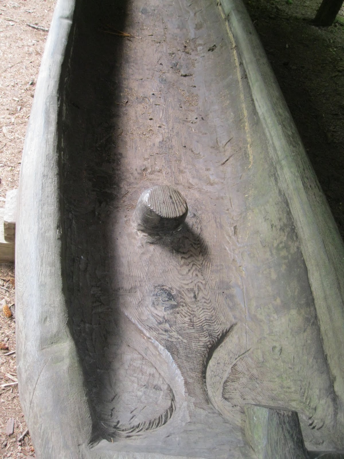
Starting at the Visitor’s Center, I hiked off into the trees toward the Yurok village, and the first thing I came to was a Yurok canoe, carved from a single redwood tree.
 The inside has a handle and something that looks like an area to sit in.

Then you walk some more until you come to the actual village. Apparently, the Yurok traditionally segregated sleeping areas, with the women and children sleeping in the regular houses, and the men sleeping in the sweathouse. This is one of their regular houses.

And this is one of the sweathouses, completely underground. Women were not allowed into the sweathouses, except for medicine women.

The entire Yurok village is set deep in the beautiful woods of Patrick's Point.
Patrick’s Point is gorgeous. The hiker/biker area is off by itself near Lookout Rock, and it is huge and covered with trees. The park itself is enormous, with three separate campgrounds and an example Yurok village. The village was constructed by modern Yuroks.

Starting at the Visitor’s Center, I hiked off into the trees toward the Yurok village, and the first thing I came to was a Yurok canoe, carved from a single redwood tree.

Then you walk some more until you come to the actual village. Apparently, the Yurok traditionally segregated sleeping areas, with the women and children sleeping in the regular houses, and the men sleeping in the sweathouse. This is one of their regular houses.

And this is one of the sweathouses, completely underground. Women were not allowed into the sweathouses, except for medicine women.

The entire Yurok village is set deep in the beautiful woods of Patrick's Point.
Wednesday, September 8, 2010
At Russian Gulch State Park
8/27/10
Making s’mores is a skill one must cultivate assiduously in order to do it well. I, unfortunately, have not cultivated it at all.
Let’s back up, just a bit. I was planning to stay at Russian Gulch State Park, just above Mendicino, and I had finished all of my supplies the night before. (I only carry enough food for a couple of days. I had tried getting only enough food for one day, but I found that was too expensive. So now, I buy a loaf of bread, mayonnaise, cheese, and lunch meat every few days, and fruit from the produce stands along the way.) So I stopped at the grocery store in Mendicino to get my fixin’s, and they had all the stuff for making s’mores in a display at the front of the store.
I stood there for a few minutes, remembering making s’mores out in the backyard with my brothers. I remembered burning most of my marshmallows, and the charred taste of the s’mores. I remembered how the marshmallows started the chocolate melting. I remembered the way it tasted. It sounded so good. So I bought a package of Hershey ’s milk chocolate bars, some Kraft marshmallows
 , and Honey Maid
 graham crackers, along with my bread, cheese, and salami.
When I got to my campsite, I bought firewood from the camp host and I started a fire. It took a long time; I’m not that good at starting fires, yet, though I am getting better.
Then I had to find a stick long enough to roast marshmallows on. You aren’t supposed to pick up wood from the ground at state campgrounds. But I wanted my s’mores, so I found one that would do and I peeled the bark back and sharpened the end. I put two marshmallows on the end and I held it up above the flames. That’s when I realized why I always burned the marshmallows. Marshmallows are basically puffed sugar. If you get it close enough to the flames to heat it, it is probably close enough to catch on fire. So I ended up with a marshmallow torch on the end of my stick. But I figured that was the way I always ate them at home, so it couldn’t hurt me. I just blew them out and went on with making my s’mores.
I had already laid out my graham crackers with my chocolate bars on top before I started burning my marshmallows, so they were all ready. I set the marshmallows on top of the chocolate bars--but they were still on the stick. How to get them off the stick? I remembered that was the hard part when I was little. So I took another graham cracker for the top, and I scraped, and I scraped, and I scraped some more. Marshmallows are really sticky when they are melted.
I finally got most of the marshmallow off the stick and on to the graham crackers and chocolate. Then, I was ready to enjoy my s’mores. I took a bite, expecting the same sensations I had when I was little. I was reminded then that a person’s tastes change as they grow. A little kid might like sweet desserts, but as the kid grows she tends to enjoy them less and less.
I guess this is just another instance of the old cliché: “You can’t go home again.”
Making s’mores is a skill one must cultivate assiduously in order to do it well. I, unfortunately, have not cultivated it at all.
Let’s back up, just a bit. I was planning to stay at Russian Gulch State Park, just above Mendicino, and I had finished all of my supplies the night before. (I only carry enough food for a couple of days. I had tried getting only enough food for one day, but I found that was too expensive. So now, I buy a loaf of bread, mayonnaise, cheese, and lunch meat every few days, and fruit from the produce stands along the way.) So I stopped at the grocery store in Mendicino to get my fixin’s, and they had all the stuff for making s’mores in a display at the front of the store.
I stood there for a few minutes, remembering making s’mores out in the backyard with my brothers. I remembered burning most of my marshmallows, and the charred taste of the s’mores. I remembered how the marshmallows started the chocolate melting. I remembered the way it tasted. It sounded so good. So I bought a package of Hershey
When I got to my campsite, I bought firewood from the camp host and I started a fire. It took a long time; I’m not that good at starting fires, yet, though I am getting better.
Then I had to find a stick long enough to roast marshmallows on. You aren’t supposed to pick up wood from the ground at state campgrounds. But I wanted my s’mores, so I found one that would do and I peeled the bark back and sharpened the end. I put two marshmallows on the end and I held it up above the flames. That’s when I realized why I always burned the marshmallows. Marshmallows are basically puffed sugar. If you get it close enough to the flames to heat it, it is probably close enough to catch on fire. So I ended up with a marshmallow torch on the end of my stick. But I figured that was the way I always ate them at home, so it couldn’t hurt me. I just blew them out and went on with making my s’mores.
I had already laid out my graham crackers with my chocolate bars on top before I started burning my marshmallows, so they were all ready. I set the marshmallows on top of the chocolate bars--but they were still on the stick. How to get them off the stick? I remembered that was the hard part when I was little. So I took another graham cracker for the top, and I scraped, and I scraped, and I scraped some more. Marshmallows are really sticky when they are melted.
I finally got most of the marshmallow off the stick and on to the graham crackers and chocolate. Then, I was ready to enjoy my s’mores. I took a bite, expecting the same sensations I had when I was little. I was reminded then that a person’s tastes change as they grow. A little kid might like sweet desserts, but as the kid grows she tends to enjoy them less and less.
I guess this is just another instance of the old cliché: “You can’t go home again.”
Tuesday, September 7, 2010
Historic Fort Ross
8/23/10
Fort Ross
I stopped at Historic Fort Ross, to get a little bit of the history of the area. Historic Fort Ross was built by the Russians, when they held part of California. I’m not sure all of it is the original fort--some of it might be reconstructed--but it is very impressive, in any case. Apparently, while the Mexicans were moving from south to north along the coast, the Russians were moving north to south along the same coast, from Alaska. The Russians brought along native hunters from Alaska to hunt seals and sea otters with devastating effect: until recently, the north American sea otter was thought to be extinct. At Fort Ross, which is only about 80 miles north of San Francisco, the Russians built such a well-fortified fort that the Spanish could not move them.
 This is one of the guard towers--there are two, one looking out to sea and the other looking inland.
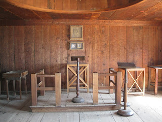 All of the buildings are not there any longer, but there are several, including the chapel, still in existence. The soldiers were, of course, Russian Orthodox, so there is an icon where western churches would have a cross.
 The chapel has an interesting barrel shaped dome in the ceiling. Unfortunately, the informative plaques did not tell me why. I would be interested to know if this had some significance in the religion. I would think it does have some significance, since none of the other buildings have anything like it.
 The dome is not for a bell, since the chapel bell is outside the door of the chapel.
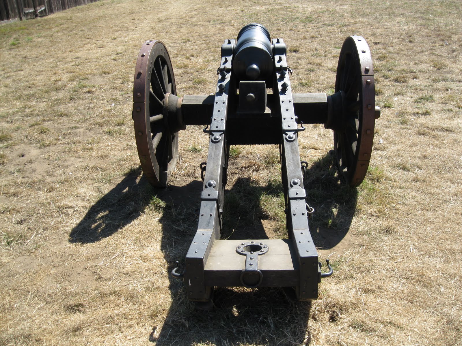
 Here are three views of the cannon. They are, now, in what would be the courtyard of the fort, but I'm sure they were kept in the guard towers in order to ward off attackers. Also, there are only four cannon on display. I wonder if they only had two for each guard tower?

The gun, itself, is very small.
There was nothing to say how big a shot it would take or how far it would throw it. I expected cannon to be larger.

 This is the armory, which is in the building that is marked as being a hotel and the commanding officer’s quarters. If they kept this many muskets, surely two cannon would not be enough--or maybe I'm just into overkill.
Fort Ross
I stopped at Historic Fort Ross, to get a little bit of the history of the area. Historic Fort Ross was built by the Russians, when they held part of California. I’m not sure all of it is the original fort--some of it might be reconstructed--but it is very impressive, in any case. Apparently, while the Mexicans were moving from south to north along the coast, the Russians were moving north to south along the same coast, from Alaska. The Russians brought along native hunters from Alaska to hunt seals and sea otters with devastating effect: until recently, the north American sea otter was thought to be extinct. At Fort Ross, which is only about 80 miles north of San Francisco, the Russians built such a well-fortified fort that the Spanish could not move them.


The gun, itself, is very small.
There was nothing to say how big a shot it would take or how far it would throw it. I expected cannon to be larger.


Subscribe to:
Posts (Atom)